Tomorrow expect 30% chance of rain showers, cloudy and a high of 55 degrees.
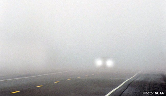
It's 3:30 pm on a New Year's Day of 2022, and the detailed forecast states continued LIGHT RAIN before 4pm. High near 55 degrees. Expect patchy fog on the roads with a wind South of 5 mph with precipitation at 100%. Continue to expect RAIN and areas of FOG before 7pm if you are traveling home for work tomorrow. Light and variable wind northeast is expected at 6mph with precipitation lowering to 90%.
Tomorrow expect 30% chance of rain showers, cloudy and a high of 55 degrees.
0 Comments
There is no White Christmas love in the forecast today to confirm next year census reports. So what do we expect for the next 6 days of December besides the rainfall today? The average temperature in New York City is 35/42 degrees F, but today's forecast predicted Saturday at noon, 49 degrees with rain? There are no active Hurricanes to watch, but the forecasters say road conditions will turn dangerous as of yesterday making slick roads throughout the travel weekend. Multiple rounds of storms will be expected to drop wintry mixtures of rain, snow and ice, which makes or creates an array of holiday travel hazards, according to the accuweather.com report. Meteorologist's say that storms for this holiday season will move along quickly and arrive approximately every other day or so. For you make up artists, be particularly careful of the significant precipitation in the air that impacts the skin which robs your face of moisture delivering dryness. Expect storms to eject potential ice which reduces the visibility on the roadways. Due to the impacts of ice for travelers today, motorist are reminded to exercise caution on the roadways overnight and in the early morning hours when ice is difficult to spot.
What is the weather like in your community today? Are you experiencing a heat wave in your area? According to the NWS, the rip currents are moderate at the beach today. Be extra careful going in to the waters.....approach the waters with caution...the winds will be 10 mph with surfs as high as 4 feet and a high UV index today in Kings County, Brooklyn. Today it will be mostly sunny with highs near 82 degrees. Remember #GunsDown and give back to your community today with a little love! #Gunviolence #kids #community The National Weather Service has posted a heat advisory warning for today in the following counties: Northern Fairfield-Northern New Haven-Northern Middlesex- Northern New London-Southern Fairfield-Southern New Haven- Western Passaic-Eastern Passaic-Hudson-Western Bergen- Eastern Bergen-Western Essex-Eastern Essex-Western Union- Eastern Union-Orange-Putnam-Rockland-Northern Westchester- Southern Westchester-New York (Manhattan)-Bronx- Richmond (Staten Island)-Kings (Brooklyn)-Northern Queens- Northern Nassau-Southern Queens-Southern Nassau- A Heat index value as high as the mid 90s will occur in the above counties so wear protective clothing and keep your head covered. Portions of northeast New Jersey, southern Connecticut and southeast New York will feel hot and humid weather today until 8 pm est this evening.. The impacts from this heat and high humidity occurrence may and will cause heat illnesses, so drink plenty of water if you are outside working or cleaning. Stay indoors if you can or visit your local malls in moderation. Expect temperatures to reach up to 96 degrees outside and there is a 60 % chance of thunderstorms. Please use caution once again when your outside today. If you are expecting sunshine today in #Brooklyn, don't. There is a slight change in plans for rain in the forecast with possible thunderstorms after the noon hour. Expect light and variable winds of 5 mph and a 20% chance of precipitation. Tonight there will be patchy fog after 5 am and a low temperature of 72 degrees. There is a 50 percent chance of rain showers and thunderstorms today so take out an umbrella. Expect mostly cloudy skies with a high near 77 degrees in Brooklyn. The East wind will be around 8 mph in the area. The current conditions in the New York City, Central Park area has an 87% humidity level and a 9.00 mile visibility currently (11:21 am). As far as the ocean conditions in the Tri-State Region, as of 3:46 am, waves of low pressure will move along a stalled frontal boundary just south of Long Island through early Saturday. This will result in unsettled weather today and tonight, so expect plenty of cloud covers out there. The current conditions for the New York Central Park area today are 73 degrees with partly sunny skies and a visibility of 10.00 miles. If your going outside today, expect possible rainfall in Brooklyn (Kings County) mainly after 9pm. The highs today will be near 82 degrees with light and variable winds becoming 6 mph northeast. The area forecast aftermath of Hurricane Isaias this morning is a weak cold front south of the area today with a series of frontal waves due to cloud covering causing instability and isolated thunder by early Friday morning. A Major Coastal Storm will continue to impact the Tri-State into Saturday. Winter Storm Riley has already caused Home Evacs in some areas. High winds and Coastal Flood Watches is now a Winter Briefing for Western Passaic, Orange and Putnam counties. The tidal coast areas of the Bronx, New York, and New Jersey are expected to experience floods around the Harbor areas. Erosion and overwashing conditions will impact vulnerable areas with high tide cycles. The gust of winds from the sea will produce 8 to 10 ft high waves causing 25 to 40 mph gusts of damaging winds which could lead to Power Outages. Heavy Wet Snow is expected in the Orange and Western Passaic Counties which could bring Damage to Tree Limbs and Powerlines. Poor Drainage flooding from the heavy rains will affect the Small Streams and Rivers in most Regions throughout to night.
Today Rain before 11am, then rain and snow. The rain could be heavy at times. Temperature falling to around 36 by 2pm. Wind chill values between 25 and 30. Windy, with a north wind 16 to 21 mph increasing to 27 to 32 mph in the afternoon. Winds could gust as high as 55 mph. Chance of precipitation is 100%. Little or no snow accumulation expected. Tonight Rain and snow, mainly before 11pm. Low around 35. Wind chill values between 25 and 30. Windy, with a north wind 25 to 32 mph, with gusts as high as 55 mph. Chance of precipitation is 90%. Little or no snow accumulation expected. Saturday A slight chance of rain and snow before 8am. Partly sunny, with a high near 46. Wind chill values between 25 and 35 early. Breezy, with a north wind 18 to 22 mph, with gusts as high as 32 mph. Chance of precipitation is 20%. Saturday Night Mostly cloudy, with a low around 34. North wind 14 to 17 mph. Sunday Mostly sunny, with a high near 45. North wind around 14 mph. Sunday Night Mostly clear, with a low around 33. When the temperature drastically drops be weather-ready for eye infections, respiratory infections and muscular spasms are caused by this change in temperature. Asthma attacks, runny noses, muscular pain, flu, pharyngitis, sinusitis, cold, sore throat, muscular aches and severe pains, are all a result of air conditioning due to a extreme variance from hot to cold in one day. Victims that suffer from coronary heart diseases, vascular cardiac, vascular brain diseases and peripheral vascular [artery and vein] diseases are prone to the sudden temperature drop that could led to exacerbating circumstances. Be resilient to global weather changes and practice resilience in weather safety preparations.
Today Rain. Temperature falling to around 35 by 3pm. Wind chill values between 25 and 35. Northeast wind 9 to 11 mph. Chance of precipitation is 80%. New precipitation amounts between a quarter and half of an inch possible. Tonight A chance of rain and sleet before 10pm. Cloudy, with a low around 33. Wind chill values between 25 and 30. Northeast wind 8 to 10 mph. Chance of precipitation is 30%. Friday Rain, mainly after 1pm. High near 42. Wind chill values between 25 and 35. East wind 7 to 9 mph. Chance of precipitation is 80%. New precipitation amounts between a tenth and quarter of an inch possible. Friday Night Rain likely, mainly before 7pm. Cloudy, with a temperature rising to around 44 by midnight. Southeast wind around 5 mph becoming west after midnight. Chance of precipitation is 60%. New precipitation amounts of less than a tenth of an inch possible. For Washington's Birthday Rain is likely, mainly after 4pm. Increasing clouds will occur with a high near 50. Expect South wind around 6 mph. There is a chance of precipitation is 60%.
Tonight Rain likely before 10pm, then a chance of drizzle or light rain, mainly between 10pm and 1am. Cloudy, with a low around 46. Southwest wind around 6 mph. Chance of precipitation is 60%. New precipitation amounts of less than a tenth of an inch possible. |
AuthorWrite something about yourself. No need to be fancy, just an overview. Archives
July 2017
Categories |