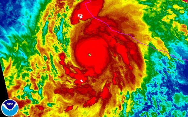
This Photo Was Captured Three Hours Ago! This is what Hurricane Patricia Looks Like And Boy Is She Angry!!!
The water temperatures are extremely warm and Hurricane Patricia is on its way to Mexico! Look Out! The intensity of 160 MPH winds are on there way when it reaches land. So what about the rain? What about Mudslides? What about Flooding? What about the catastrophic effects for tomorrow? Are you Weather-Ready People?
At 8:00 am EDT, the tropical weather outlook for the Mexico area currently states there are no cyclone activity for the next 48 hours, however, cyclones is what determines the Hurricane Strength within the Caribbean Sea and the Gulf of Mexico. When storms are formed in the Atlantic basin during the month of September, the waters become depressed just like people. Hurricanes and how and when they form is from the studies spanning over 30 years (1981-2010) according to the climatology reports. However, when Accumulated Cyclones of Energy is measured for storm and hurricane activity, the Atlantic basin is the determinate of Wind currents listed by dates of Expectation. So who was invited into our world since May? Well, you have TS Ana, TS Bill, TS Claudette, MH Danny, TS Erika, H Fred, TS Grace, TS Henri, TD Nine, TS Ida, MH Joaquin on September 28, 2015. Wow, talking about joining the conversation....so why so much anger? Well, one reason is the Tropical Weather. Hurricane season for the Atlantic area is June 1st through November 30, 2015. So Hurricane tracking is of the utmost importance to a National Weather Ambassador (who has been busy ~ yet depressingly interrupted). So let's Get Social about Hurricane Patricia! According to the Mexican Government, Hurricane Patricia is a Tropical Storm Warning thus far that is heading for the coast of Mexico North of San Blas to El Roblito. A Tropical Storm Warning means conditions are expected in the area only! Now for the Eastern Pacific Hurricane season the timeframe is May 15th and ends November 30th. What to expect about Hurricane Patricia? A Hurricane!!! On the Eastern Pacific side of the World, Hurricane Patricia is moving Northward toward the landfall in Southwestern Mexico. The Winds Are currently 105.5 MPH and the Mexican Government has issued a Tropical Storm Warning for the coast of Mexico north of San Blas to El Roblito. Within the next 24 hours a Hurricane condition is expected to sustain winds at 200 MPH (325 km/h). A Category 5 hurricane people!! The NOAA Hurricane Hunter aircraft is scheduled to investigate Patricia before landfall. If you are not prepared, get Hurricane prepared now!!!!
Get A Plan! ~ Evacuate and identify your hurricane risks!
Take Action! ~ Remember Tropical Storm Allison that produced more than 40 inches of rain in 2001, causing about $5 billion in damage and taking the lives of 41 people. Let's not forget South Carolina recently, 2015, and the loss of lives due to the storm surge. Flashlights, Generators, Battery-Operated Equipment (Cellphone)
Buy Food! ~ Store Drinking Water
Buy Plywood!
Trim Trees!
Clear Clogged Rain Gutters!
Review Your Insurance Policy!
Don't Forget Your Pet!
Post Emergency Telephone Numbers!
Remember the NOAA Weather Radio All Hazards continuous broadcasting warning service. The Emergency/Preparedness Information at the American Red Cross: www.recross.org FEMA: www.fem.gov
Now For All You New Yorkers ~ What is your Weather Like Today?
Sunny - high 60 degrees; Tonight - clear around 44 degrees All Clear Skies....
#Hurricanesafety
 RSS Feed
