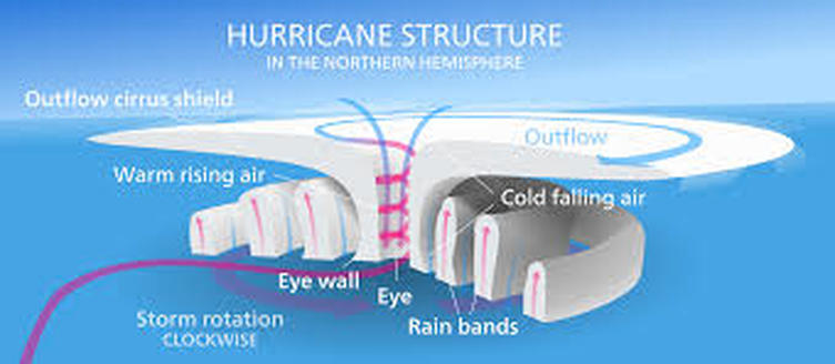
When high pressure enters the Eastern Canada dry weather flows causing temperatures to become high, sometimes violent (storms) or tropical (normally by the Atlantic or Pacific Oceans) and this is called a Hurricane. Tropical cyclones normally use warm, moist air to fuel their energy and forms over a warm ocean water near the Equator. As the moist air rises upward, the air begins to rise and lower air pressure will push new air. This reactions leads to warmed moist air that rises and cools off of the water to form clouds, winds, and growth fed by the ocean's heat and water evaporating from the surface. As the storm rotates faster and faster, an eye forms in the center causing higher pressure air inside the eye as the winds rotate and reach extremely high wind mph's. The stronger the winds the increase in chances that a Hurricane will happen.
3 Day Forecast
Today
Sunny, with a high near 58. Northeast wind 6 to 8 mph becoming south in the afternoon.
Tonight
Clear, with a low around 42. South wind around 6 mph becoming calm in the evening.
Friday
Sunny, with a high near 62. Northeast wind around 7 mph.
Friday Night
Clear, with a low around 43. North wind 3 to 6 mph.
Saturday
Sunny, with a high near 63. Northeast wind around 10 mph.
Saturday Night
Mostly clear, with a low around 46.
 RSS Feed
