A cold front has been posted for the Southeastern NY.......Northeastern NJ and Southern CT at 3:48 am EST! Snow will move in across the interior today with rain near the coast. However, a Cold Front will approach the West Late in the day. It has been mentioned that temperatures will remain Chilly today in NYC and is currently 28 degrees.
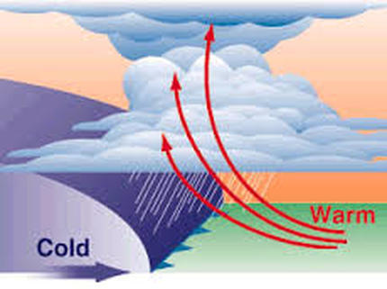
So what causes a cold front?
Usually cooler air mass that moves into warmer air that we had experienced in the past to wake up a developing extratropical cyclone. When warmer air interacts with cooler air mass, precipitation is usually produces .
So what are the impacts of Weather Fronts?
Weather fronts are just like fighting in the Military or an Army without amo! No Guns! No Grenades! No Fighter Jets! Who!!!! When someone fights on the ground or face to face (as I did with my former boyfriend), you must understand how to fight and when to fight! Fighting lines, just like Cold Fronts or Weather Fronts require lines of men or lines of air that have been assigned a specific job. It is a front line fighting the shielded soldier forges ahead to protect those behind it. So, when there is a line of an army, the Fronts are the contact zones between two different air masses like advancing armies or Different Pressure, Density, Temperature and Moisture. Conflict happens when Battling Armies or Air Masses - Cold Fronts/Weather Fronts create changes in weather conditions. There are Four Types of Fronts - Cold Front, Warm Front, Stationary Front, and Occluded Front. What are the colors then? Blue for Cold, and Red for Warm.
So for Cold Front - or contact the boundaries is advancing cold air mass. For Warm Front - or contact the boundaries is advancing warm air mass to attack over what is known as stationary cold front air mass to win a fight!!!! And finally, just when you thought it was over, an occluded front - or cold front overtakes a warm front as in today. Guess what happens? A Surprise Attack or Thunderstorms......or Possible Snow!!! So Dramatic isn't it and comes quick just like your body reacting to Water.........when your step into a pool or hot pool. Wow!
So Today....your forecasts will be and for the rest of the week:
Today
A chance of snow between noon and 2pm, then rain likely. Mostly cloudy, with a high near 40. Wind chill values between 25 and 30. South wind 8 to 17 mph, with gusts as high as 28 mph. Chance of precipitation is 60%. Little or no snow accumulation expected.
Tonight
A chance of snow showers, mainly before 9pm. Mostly cloudy, with a low around 25. Wind chill values between 15 and 25. Breezy, with a west wind 16 to 23 mph, with gusts as high as 33 mph. Chance of precipitation is 40%.
Wednesday
Mostly sunny, with a high near 32. Wind chill values between 10 and 20. Breezy, with a west wind 15 to 20 mph, with gusts as high as 34 mph.
Wednesday Night
Partly cloudy, with a low around 23. Wind chill values between 15 and 20. West wind 9 to 13 mph.
Thursday
Partly sunny, with a high near 37. West wind 8 to 10 mph.
Thursday Night
Mostly cloudy, with a low around 31.
Friday
Partly sunny, with a high near 44.
Friday Night
A chance of rain. Mostly cloudy, with a low around 36. Chance of precipitation is 50%.
Saturday
Rain likely, mainly after 2pm. Cloudy, with a high near 44. Chance of precipitation is 70%.
Saturday Night
A chance of rain before 4am, then a chance of snow. Mostly cloudy, with a low around 31. Chance of precipitation is 30%.
Sunday
Partly sunny, with a high near 36.
Sunday Night
Mostly cloudy, with a low around 26.
M.L.King Day
Mostly sunny, with a high near 31.
#wintersafety
 RSS Feed
