There is a Wind Advisory Today! It will go into effect from 6 pm this evening until 4 am EST Thursday. Please take precautions in the New York City ...... Long Island ..... and Coastal Connection locations.
Hazardous winds will come from the South at 25 to 25 MPH with Gusts 45 to 50 MPH. Timing for this evening when traveling home is to be WEATHER RESILIENT!!!!
Impacts to power, driving and trees could happen in your areas so preparedness actions are necessary!
When sustained winds reach 31 to 39 MPH or Gust up to 46 to 57 MPH.....expect Floods after 6 pm Thursday morning, Cold Fronts, and Thunderstorms.......poor drainage in areas could be a major problem due to Streams and Small Rivers.
So What is the weather like in your Forecast?:
Today
Periods of sprinkles, mainly before 11am, then rain after 11am. Areas of fog. High near 52. Northeast wind 8 to 13 mph becoming southeast in the afternoon. Chance of precipitation is 100%. New precipitation amounts between a quarter and half of an inch possible.
Tonight
Showers and possibly a thunderstorm before 3am, then a chance of showers. Some of the storms could produce small hail and gusty winds. Areas of fog. Low around 49. Windy, with a south wind 26 to 31 mph decreasing to 18 to 23 mph after midnight. Chance of precipitation is 100%. New rainfall amounts between a half and three quarters of an inch possible.
Thursday
A slight chance of showers. Mostly cloudy, with a high near 53. Southwest wind 15 to 17 mph, with gusts as high as 28 mph. Chance of precipitation is 20%.
Thursday Night
Mostly cloudy, with a low around 32. Wind chill values between 25 and 30. West wind around 16 mph.
Friday
Mostly sunny, with a high near 38. Northwest wind 15 to 18 mph, with gusts as high as 30 mph.
Friday Night
Partly cloudy, with a low around 27.
Saturday
Mostly sunny, with a high near 40.
Saturday Night
Partly cloudy, with a low around 35.
Sunday
Mostly sunny, with a high near 51.
Sunday Night
Partly cloudy, with a low around 41.
Monday
Partly sunny, with a high near 53.
Monday Night
Partly cloudy, with a low around 32.
Tuesday
Mostly sunny, with a high near 44.
Wind Advisory
Hazardous Weather Outlook
Today: Periods of sprinkles, mainly before 11am, then rain after 11am. Areas of fog. High near 52. Northeast wind 8 to 13 mph becoming southeast in the afternoon. Chance of precipitation is 100%. New precipitation amounts between a quarter and half of an inch possible.
Tonight: Showers and possibly a thunderstorm before 3am, then a chance of showers. Some of the storms could produce small hail and gusty winds. Areas of fog. Low around 49. Windy, with a south wind 26 to 31 mph decreasing to 18 to 23 mph after midnight. Chance of precipitation is 100%. New rainfall amounts between a half and three quarters of an inch possible.
Thursday: A slight chance of showers. Mostly cloudy, with a high near 53. Southwest wind 15 to 17 mph, with gusts as high as 28 mph. Chance of precipitation is 20%.
Thursday Night: Mostly cloudy, with a low around 32. Wind chill values between 25 and 30. West wind around 16 mph.
Friday: Mostly sunny, with a high near 38. Northwest wind 15 to 18 mph, with gusts as high as 30 mph.
Friday Night: Partly cloudy, with a low around 27.
Saturday: Mostly sunny, with a high near 40.
Saturday Night: Partly cloudy, with a low around 35.
Sunday: Mostly sunny, with a high near 51.
Sunday Night: Partly cloudy, with a low around 41.
Monday: Partly sunny, with a high near 53.
Monday Night: Partly cloudy, with a low around 32.
Tuesday: Mostly sunny, with a high near 44.
REMEMBER:
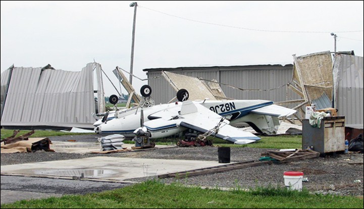
High winds can occur during a severe thunderstorm, with a strong weather system, or can flow down a mountain. When winds are sustained at 40-50 mph, isolated wind damage is possible. Widespread significant wind damage can occur with higher wind speeds. During strong thunderstorms, straight line wind speeds can exceed 100 mph. High winds can blow objects around and pose a significant threat to your safety. Understanding the risks can help you prepare for these events.
#WINDSAFETY
Hazardous winds will come from the South at 25 to 25 MPH with Gusts 45 to 50 MPH. Timing for this evening when traveling home is to be WEATHER RESILIENT!!!!
Impacts to power, driving and trees could happen in your areas so preparedness actions are necessary!
When sustained winds reach 31 to 39 MPH or Gust up to 46 to 57 MPH.....expect Floods after 6 pm Thursday morning, Cold Fronts, and Thunderstorms.......poor drainage in areas could be a major problem due to Streams and Small Rivers.
So What is the weather like in your Forecast?:
Today
Periods of sprinkles, mainly before 11am, then rain after 11am. Areas of fog. High near 52. Northeast wind 8 to 13 mph becoming southeast in the afternoon. Chance of precipitation is 100%. New precipitation amounts between a quarter and half of an inch possible.
Tonight
Showers and possibly a thunderstorm before 3am, then a chance of showers. Some of the storms could produce small hail and gusty winds. Areas of fog. Low around 49. Windy, with a south wind 26 to 31 mph decreasing to 18 to 23 mph after midnight. Chance of precipitation is 100%. New rainfall amounts between a half and three quarters of an inch possible.
Thursday
A slight chance of showers. Mostly cloudy, with a high near 53. Southwest wind 15 to 17 mph, with gusts as high as 28 mph. Chance of precipitation is 20%.
Thursday Night
Mostly cloudy, with a low around 32. Wind chill values between 25 and 30. West wind around 16 mph.
Friday
Mostly sunny, with a high near 38. Northwest wind 15 to 18 mph, with gusts as high as 30 mph.
Friday Night
Partly cloudy, with a low around 27.
Saturday
Mostly sunny, with a high near 40.
Saturday Night
Partly cloudy, with a low around 35.
Sunday
Mostly sunny, with a high near 51.
Sunday Night
Partly cloudy, with a low around 41.
Monday
Partly sunny, with a high near 53.
Monday Night
Partly cloudy, with a low around 32.
Tuesday
Mostly sunny, with a high near 44.
Wind Advisory
Hazardous Weather Outlook
Today: Periods of sprinkles, mainly before 11am, then rain after 11am. Areas of fog. High near 52. Northeast wind 8 to 13 mph becoming southeast in the afternoon. Chance of precipitation is 100%. New precipitation amounts between a quarter and half of an inch possible.
Tonight: Showers and possibly a thunderstorm before 3am, then a chance of showers. Some of the storms could produce small hail and gusty winds. Areas of fog. Low around 49. Windy, with a south wind 26 to 31 mph decreasing to 18 to 23 mph after midnight. Chance of precipitation is 100%. New rainfall amounts between a half and three quarters of an inch possible.
Thursday: A slight chance of showers. Mostly cloudy, with a high near 53. Southwest wind 15 to 17 mph, with gusts as high as 28 mph. Chance of precipitation is 20%.
Thursday Night: Mostly cloudy, with a low around 32. Wind chill values between 25 and 30. West wind around 16 mph.
Friday: Mostly sunny, with a high near 38. Northwest wind 15 to 18 mph, with gusts as high as 30 mph.
Friday Night: Partly cloudy, with a low around 27.
Saturday: Mostly sunny, with a high near 40.
Saturday Night: Partly cloudy, with a low around 35.
Sunday: Mostly sunny, with a high near 51.
Sunday Night: Partly cloudy, with a low around 41.
Monday: Partly sunny, with a high near 53.
Monday Night: Partly cloudy, with a low around 32.
Tuesday: Mostly sunny, with a high near 44.
REMEMBER:
High winds can occur during a severe thunderstorm, with a strong weather system, or can flow down a mountain. When winds are sustained at 40-50 mph, isolated wind damage is possible. Widespread significant wind damage can occur with higher wind speeds. During strong thunderstorms, straight line wind speeds can exceed 100 mph. High winds can blow objects around and pose a significant threat to your safety. Understanding the risks can help you prepare for these events.
#WINDSAFETY
 RSS Feed
