The National Weather Service has posted a Watch Warning and Advisory today in Arcadia, Louisiana at around 3:49 am CDT today.
The following Parishes are under a Hazardous Weather Outlook for portions of the South Central Regions:
LAFAYETTE-COLUMBIA-UNION-CADDO-BOSSIER-WEBSTER-CLAIBORNE-LINCOLN- DE SOTO-RED RIVER-BIENVILLE-JACKSON-OUACHITA-SABINE-NATCHITOCHES- WINN-GRANT-CALDWELL-LA SALLE-FRANKLIN-TITUS-CAMP-MORRIS-CASS-WOOD- UPSHUR-MARION-SMITH-GREGG-HARRISON-CHEROKEE-RUSK-PANOLA- NACOGDOCHES-SHELBY-ANGELINA-SAN AUGUSTINE-
Please be on the look out for Severe Thunderstorms.......damaging Wind Gusts and Isolated Tornadoes today. This severe weather threat will continue to threaten the areas with heavy rainfall and levels of disturbances with the Regions of the Southwest. A Flash Flood Watch is Necessary for portions of these Regions tonight into Saturday. Although the chances of Thunderstorms are at 50% today the Forecast calls for:
A 50 percent chance of showers and thunderstorms. Mostly cloudy, with a high near 85. South wind 10 to 15 mph.
Tonight
Showers and thunderstorms. Some of the storms could produce heavy rainfall. Low around 67. Southeast wind 10 to 15 mph. Chance of precipitation is 90%.
Saturday
Showers and thunderstorms likely. Mostly cloudy, with a high near 82. South wind 10 to 15 mph. Chance of precipitation is 70%.
Saturday Night
A 50 percent chance of showers and thunderstorms. Mostly cloudy, with a low around 64. South wind around 5 mph becoming calm after midnight.
Sunday
A 20 percent chance of showers and thunderstorms. Partly sunny, with a high near 85. North wind around 5 mph.
Sunday Night
A 20 percent chance of showers and thunderstorms. Partly cloudy, with a low around 60.
Monday
A 40 percent chance of showers and thunderstorms. Partly sunny, with a high near 74.
Monday Night
A 40 percent chance of showers and thunderstorms. Mostly cloudy, with a low around 58.
Tuesday
A 20 percent chance of showers and thunderstorms. Partly sunny, with a high near 74.
Tuesday Night
Partly cloudy, with a low around 56.
Wednesday
Mostly sunny, with a high near 76.
Wednesday Night
Mostly clear, with a low around 56.
Thursday
Sunny, with a high near 78.
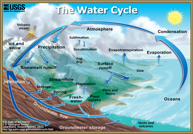
Please click onto the link below to understand more about Water Science during Flood Advisories:
http://water.usgs.gov/edu/watercycle.html
For New Yorkers The Severe Weather Awareness Week 2016 Continues:
Potential Flood Watches within the next 26 hours
Flash Food Warnings create immediate threats to life and property
Be extremely careful while driving today.................
New Yorkers Forecast Calls For:
A chance of rain, mainly after 1pm. Cloudy, with a high near 56. East wind 8 to 10 mph. Chance of precipitation is 40%.
Tonight
Rain likely, mainly before midnight. Cloudy, with a low around 46. East wind around 7 mph becoming northeast after midnight. Chance of precipitation is 70%. New precipitation amounts between a tenth and quarter of an inch possible.
Saturday
Partly sunny, with a high near 62. Northeast wind 6 to 8 mph becoming southeast in the afternoon.
Saturday Night
A chance of rain, mainly after 2am. Increasing clouds, with a low around 47. Southeast wind 5 to 11 mph. Chance of precipitation is 30%.
Sunday
Rain likely, mainly after 8am. Cloudy, with a high near 56. East wind 7 to 13 mph. Chance of precipitation is 60%. New precipitation amounts between a half and three quarters of an inch possible.
Sunday Night
Rain likely. Cloudy, with a low around 50. Chance of precipitation is 60%. New precipitation amounts between a quarter and half of an inch possible.
Monday
A chance of rain. Cloudy, with a high near 60. Chance of precipitation is 50%.
Monday Night
Mostly cloudy, with a low around 49.
Tuesday
Partly sunny, with a high near 64.
Tuesday Night
Mostly cloudy, with a low around 50.
Wednesday
Partly sunny, with a high near 64.
Wednesday Night
Mostly cloudy, with a low around 51.
Thursday
A chance of showers. Mostly cloudy, with a high near 64. Chance of precipitation is 30%.
#springsafety
The following Parishes are under a Hazardous Weather Outlook for portions of the South Central Regions:
LAFAYETTE-COLUMBIA-UNION-CADDO-BOSSIER-WEBSTER-CLAIBORNE-LINCOLN- DE SOTO-RED RIVER-BIENVILLE-JACKSON-OUACHITA-SABINE-NATCHITOCHES- WINN-GRANT-CALDWELL-LA SALLE-FRANKLIN-TITUS-CAMP-MORRIS-CASS-WOOD- UPSHUR-MARION-SMITH-GREGG-HARRISON-CHEROKEE-RUSK-PANOLA- NACOGDOCHES-SHELBY-ANGELINA-SAN AUGUSTINE-
Please be on the look out for Severe Thunderstorms.......damaging Wind Gusts and Isolated Tornadoes today. This severe weather threat will continue to threaten the areas with heavy rainfall and levels of disturbances with the Regions of the Southwest. A Flash Flood Watch is Necessary for portions of these Regions tonight into Saturday. Although the chances of Thunderstorms are at 50% today the Forecast calls for:
A 50 percent chance of showers and thunderstorms. Mostly cloudy, with a high near 85. South wind 10 to 15 mph.
Tonight
Showers and thunderstorms. Some of the storms could produce heavy rainfall. Low around 67. Southeast wind 10 to 15 mph. Chance of precipitation is 90%.
Saturday
Showers and thunderstorms likely. Mostly cloudy, with a high near 82. South wind 10 to 15 mph. Chance of precipitation is 70%.
Saturday Night
A 50 percent chance of showers and thunderstorms. Mostly cloudy, with a low around 64. South wind around 5 mph becoming calm after midnight.
Sunday
A 20 percent chance of showers and thunderstorms. Partly sunny, with a high near 85. North wind around 5 mph.
Sunday Night
A 20 percent chance of showers and thunderstorms. Partly cloudy, with a low around 60.
Monday
A 40 percent chance of showers and thunderstorms. Partly sunny, with a high near 74.
Monday Night
A 40 percent chance of showers and thunderstorms. Mostly cloudy, with a low around 58.
Tuesday
A 20 percent chance of showers and thunderstorms. Partly sunny, with a high near 74.
Tuesday Night
Partly cloudy, with a low around 56.
Wednesday
Mostly sunny, with a high near 76.
Wednesday Night
Mostly clear, with a low around 56.
Thursday
Sunny, with a high near 78.
Please click onto the link below to understand more about Water Science during Flood Advisories:
http://water.usgs.gov/edu/watercycle.html
For New Yorkers The Severe Weather Awareness Week 2016 Continues:
Potential Flood Watches within the next 26 hours
Flash Food Warnings create immediate threats to life and property
Be extremely careful while driving today.................
New Yorkers Forecast Calls For:
A chance of rain, mainly after 1pm. Cloudy, with a high near 56. East wind 8 to 10 mph. Chance of precipitation is 40%.
Tonight
Rain likely, mainly before midnight. Cloudy, with a low around 46. East wind around 7 mph becoming northeast after midnight. Chance of precipitation is 70%. New precipitation amounts between a tenth and quarter of an inch possible.
Saturday
Partly sunny, with a high near 62. Northeast wind 6 to 8 mph becoming southeast in the afternoon.
Saturday Night
A chance of rain, mainly after 2am. Increasing clouds, with a low around 47. Southeast wind 5 to 11 mph. Chance of precipitation is 30%.
Sunday
Rain likely, mainly after 8am. Cloudy, with a high near 56. East wind 7 to 13 mph. Chance of precipitation is 60%. New precipitation amounts between a half and three quarters of an inch possible.
Sunday Night
Rain likely. Cloudy, with a low around 50. Chance of precipitation is 60%. New precipitation amounts between a quarter and half of an inch possible.
Monday
A chance of rain. Cloudy, with a high near 60. Chance of precipitation is 50%.
Monday Night
Mostly cloudy, with a low around 49.
Tuesday
Partly sunny, with a high near 64.
Tuesday Night
Mostly cloudy, with a low around 50.
Wednesday
Partly sunny, with a high near 64.
Wednesday Night
Mostly cloudy, with a low around 51.
Thursday
A chance of showers. Mostly cloudy, with a high near 64. Chance of precipitation is 30%.
#springsafety
 RSS Feed
