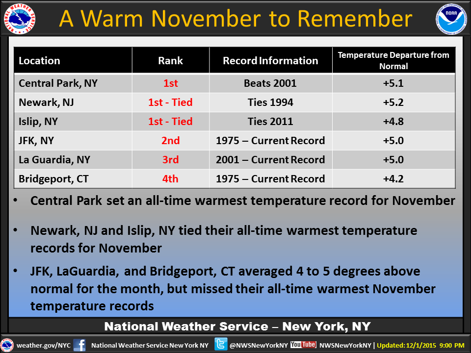
According to the National Weather Service in New York City, we are experiencing an extremely warm Winter this year since 2001. The last time Newark, New Jersey experienced this type of weather was in 1994. As you know, in order to be a Force of Nature: to prepare and stay safe for #wintersafety this year, you must understand what you are dealing with when it comes to weather-related incidents. This year let's focus on why it is still warm and then drive into why you need to be resilient to weather-related vehicle crashes before the snow falls.
As we discussed in earlier post, El Nino, the husband to La Nina, is an El Nino-Southern Oscillation (ENSO) that naturally occurs during fluctuating ocean temperatures in the equatorial Pacific when the waters are warmer as is sloshes, oscillates, and rocks back and forth across the Pacific. Just like your Bathtub when running water. For a better understanding globally, due to this "Bathtub" effect that causes a dominant force of variations in regional climate patterns, the warmer the Water becomes the warmer El Nino will effect Winter Weather patterns based upon the "Bathtub" running water to respond to change in the air (precipitation). Just like a "Bathtub" that fills steam into the air. Since El Nino is not talking to his wife currently to make this cooler within their relationship, the western equatorial Pacific will not effect our area with cooler temperatures. Did New Yorkers experience a lot of rain this year? Reflect back to this summer and this will explain why such a warm winter is amongst us based upon El Nino's events and the hurricane seasons within the Caribbean's and Atlantic during (June through November). The less rainfall, the less winter precipitation.
As the phase of La Nina approaches this year to deliver stronger atmospheric winds across the equator, jet streams of air from the La Nina conditions this year in North Carolina events will increase the impacts of how Being A Force Of Nature this winter is important. Environmental conditions on food from the weather patterns causing evapotranspiration is to be Weather Resilient on Crops.
Here is your 5 day forecast for New York City:
Today
Occasional showers. Areas of fog. High near 57. Calm wind becoming east around 6 mph in the afternoon. Chance of precipitation is 100%. New precipitation amounts between a half and three quarters of an inch possible.
Tonight
Occasional showers, mainly before 10pm. Areas of fog before 8pm. Low around 46. South wind 8 to 10 mph becoming west after midnight. Chance of precipitation is 80%. New precipitation amounts between a tenth and quarter of an inch possible.
Thursday
Mostly sunny, with a steady temperature around 48. West wind 14 to 18 mph.
Thursday Night
Mostly clear, with a low around 39. West wind 10 to 16 mph.
Friday
Sunny, with a high near 51. Northwest wind 8 to 10 mph.
Friday Night
Mostly clear, with a low around 38.
Saturday
Sunny, with a high near 50.
Saturday Night
Mostly clear, with a low around 41.
Sunday
Sunny, with a high near 54.
Sunday Night
Partly cloudy, with a low around 43.
Monday
Sunny, with a high near 51.
Monday Night
Partly cloudy, with a low around 39.
Tuesday
A chance of rain. Partly sunny, with a high near 50. Chance of precipitation is 30%.
 RSS Feed
